
--> page Web en
Pipeline ROV video inspection survey
(Quicktime movie 3.1Mb)
![]()
(Copetech Cie, Marseille)
![]()
to visualize the above QT movie
GeoMovie
Geospatial digital video encoder
Georeferenced movie recording
GPS-based video mapping
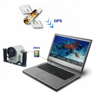
How to get embedding GPS position into video ?
That's to answer to this question that M.I.S. has developed the GeoPict/GeoMovie technology allowing the integration of sensors data such as GPS into digital compressed movies to create spatially encoded video.
Lat/lon geographical position burn-in to digital video : an innovative concept
Contrarily to other existing solutions on the market which encode date and position data in the audio track of a video tape, the geospacial video encoder is 100% digital solution.
The other hardware systems converts GPS data received from the GPS receiver into a audio signal, so each GPS point is associated with a time code on the video, allowing the video to be referenced by the indexed GPS data.
The problem is that the integration of GPS data enables video indexing and review only with dedicated proprietary desktop mapping software or via some extension tool to GIS environment, used to decode the GPS data in the audio signal and create an index that can be used to reference the video by time and space.
GeoMovie, an open technology : with GPS encoding/decoding format not proprietary
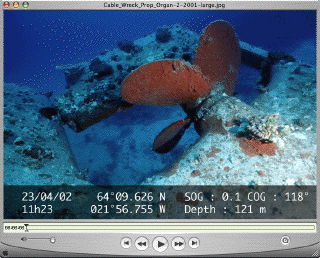
With our GeoMovie software, the compressed images are directly tagged or stamped with info from the sensors : the .mov video sequence is matched with a .data navigation text file to create a georeferenced video sequence.
- geographic location tag (plus automated additional data logging) on digital images :
-> each video frame is time & position stamped by the GPS with open XML format
So with GeoMovie concept, any third application such as GIS can use the created GeoMovie file.
Software features :
The first application of GeoMovie was studied for underwater video mapping with a ROV : seabed imaging and mapping survey.
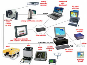
Tracking and positioning of the ROV are provided by a ultra-short baseline acoustic tracking system.
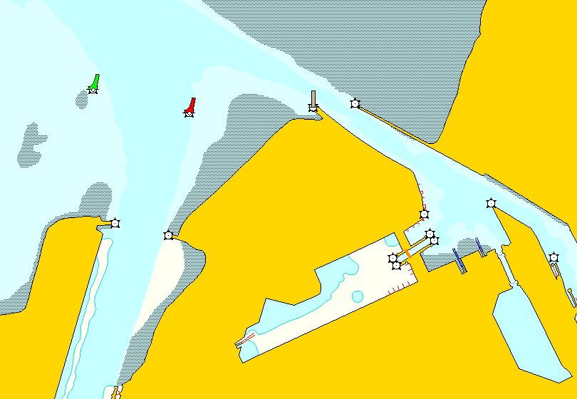
This underwater system is interfaced to the vessel survey navigation system and provides realtime x,y,z positioning of the ROV in an ECS (Electronic Chart System).
So Olex ECS plots on a vector map and in real-time vessel and ROV tracklines. A special IO driver designed by MIS also provides data streams coming from GPS and ROV sensors via a UDP NMEA server to a Apple Powerbook laptop used to record and compress video images.
Finally, the goal of GeoMovie is to provide the means to access large librairies of geo-referenced digital video.
Thus, the encoded video data can then be accessed and manipulated digitally, significally reducing the time and cost required to review and edit the inspection data.
- the GeoMovie system is directly connected to a digital video source and also to the sensors via Olex.
- the Mac collects the data (position , heading and speed of the vessel and ROV, ROV altitude)
- the file containing the NMEA data from the sensors is an ASCII XML file with GPX format (GPS eXchange) usable by any text editor, spreadsheet or database tool
- video is recorded in real time on the GeoMovie system with the sensors data
- live video interface to display and capture the images in real time from whatever video camera
- direct access to the images and video sequences (automatic positioning via mouse click)
- possibilty to use the features of the Apple Final Cut software to work on the recorded movie :
save on DVD or other formats, extractions, generation of resumes
- the recorded sensor data are synchronized with the video images then directly compressed with Quicktime® MPEG-4 video codec
- with possibility to have a GPS video overlay (or other data such as time and heading for example)
- associated with a cam recorder, GeoMovie allows a video live recording with a data overlay (data customized by the user for individual needs and displayed in transparence in some title blocks)
- the adding of references such as date, time and position allows to reference movies geographically in a G.I.S. (Geographical Information System) such as the Olex marine ECS.
- interfaced with the Olex software for example, GeoMovie allows to visualize in real time :
- on a first screen the track of a ROV -in 2D on the electronic chart and in 3D upon the seafoor virtual representation-, with possibilities to make distance calculations, comments...
- and on a second screen the video taking from the ROV
- interfaced with depth echo-sounders providing info about acoustic seabed classification, GeoMovie allows to create from the video images charts a better classification scheme for seafloor habitats (precision mapping of th seashore substrate and identification of specific seafloor targets and superficial sediments)
- interfaced with the Olex software for example, GeoMovie allows to visualize in real time :
Direct correlation of video with survey sensor datasets :
Actually, GeoMovie gives a simple possibility to users to access archives of survey data by associating high resolution underwater video and 2D/3D geographical data (digital hydrographic charts, bathymetry and seafloor mapping, ROV trajectory, field layouts).
GeoMovie is a pure software solution : it removes the requirement to have dedicated in-house review systems, including SVHS recorders and monitors, since the video can be viewed together with other spatial information directly from the desktop PC.
GeoMovie is also an efficient tool for enhanced quality reporting and analysis in the offshore sector (for example, taking snapshots and video clips of points of interest and including them in e-reports).
GeoMovie is still in development : today the search for video in the video database is only manual (with files name). We plan to implement a video access searching by clicking a point along the video route (or easting/northing) and key phrase (date and time).
Customization :
Other features could be added on demand for any potential application
Different measuring devices can be used in GeoMovie (temperature, salinity probes -any kind of device with digital format)
GeoMovie system :
GeoMovie is not sold as a standalone software
but as a complete digital video capture, review, and geo-encoding system.
The choice of the capacity of the internal computer used for capturing video, synchronising with survey data and automatically archiving depends on the duration of the video survey and on the quality of the images.
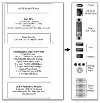
- GPS receiver with RS232 or USB interface (output messages : $GPRMC sentence or $GPGGA and $GPZDA) :
bauds rate, data/stop bits number, parity selectable in GeoMovie
Note : precision video time inserter allowing fail safe synchronization to GPS (video timestamping) can be realized with GPS fitted with PPS (Pulse Per Second) output and NTP (Network Time Protocol) software providing millisecond of time
required for reporting with marine survey data integration in Olex Linux software :
- Olex software with underwater systems tracking (Nautilus 3D module) and 3D seafloor mapping
- option : Olex bottom classification module to characterize the bottom hardness
with Stenmar RoxAnn or Simrad EK60/EY60 systems - underwater acoustic positioning system (Trackpoint II ORE or HPR300P HPR400P Simrad)