Currents module
In September 2006, with version 6.4, Olex introduced automatic computation of tidal currents and their display on the chart.
Olex had been the first system to let users create their own seabed relief maps with the vessel’s GPS and echo sounder. It now lets navigators create their own current maps with their sensors. The currents module, based on a drift computation, reuses the database model of Olex bathymetry: filtering and accumulating GPS and compass data over time.
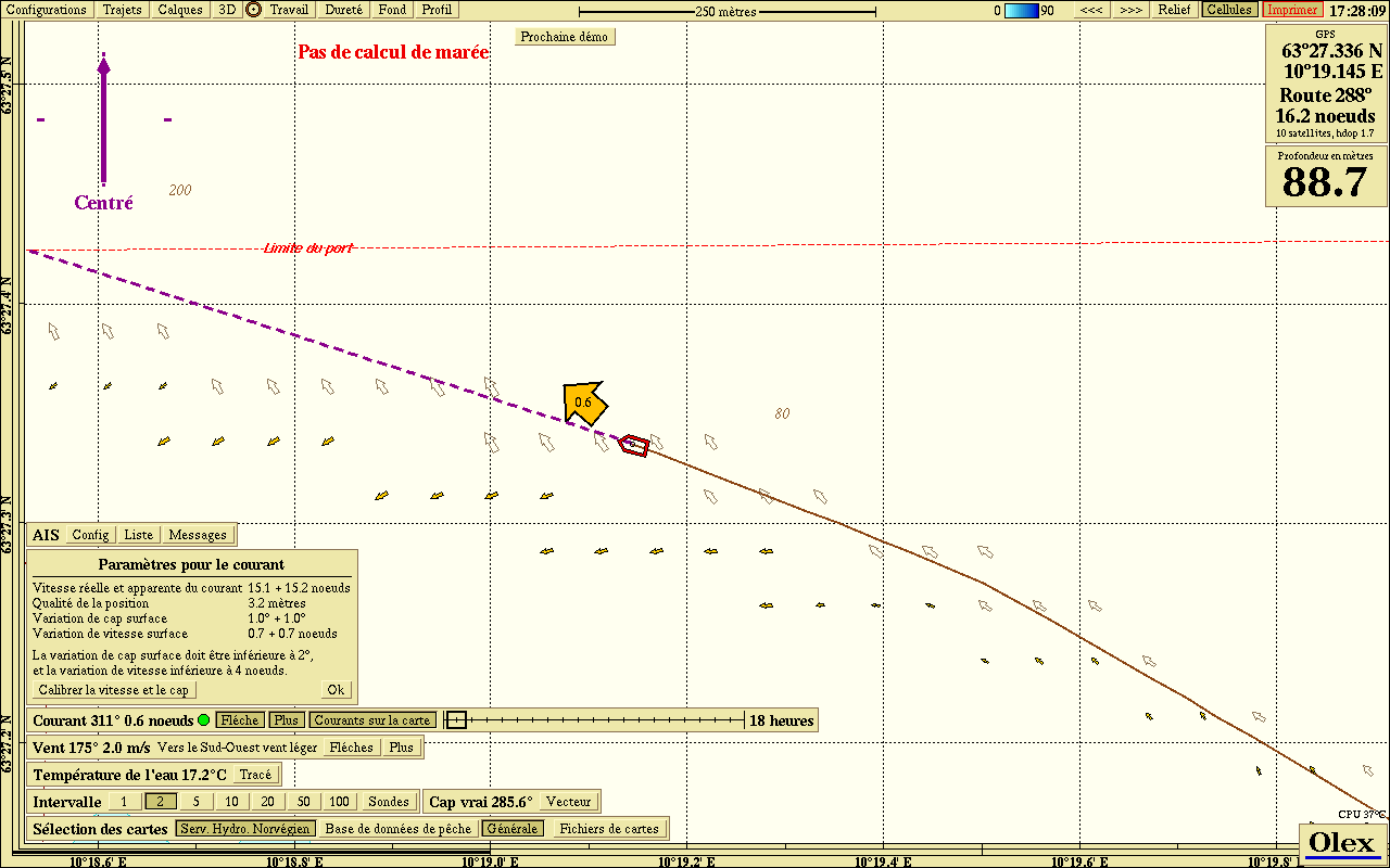 Current map generation
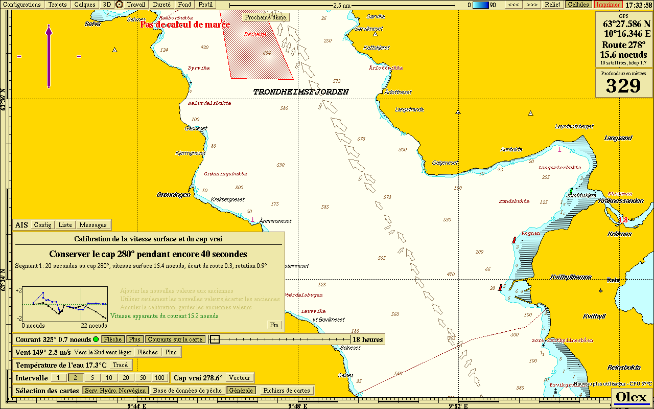 Sensor calibration
The principle
From the NMEA data of the GPS and gyrocompass (position, speed and course over ground, true heading, speed through water), Olex computes the vessel’s drift over the ground and displays it as an arrow of variable size from the vessel. This drift represents the current.
Results are excellent for tidal currents, which are regular and predictable, and are only limited by the resolution of the sensors. Offshore, where tidal currents are weak, general ocean currents are seldom cyclical and harder to compute: oceanographic data from satellite altimetry (Topex/Poseidon, ERS, Envisat, Jason) must then be used.
Currents are mapped in a cell structure similar to that of the bathymetric database, with a coarser resolution. The map takes the main tidal phase into account: for a given position, currents are sorted into time slots synchronised with the angle of the Moon relative to the Earth (M2 harmonic constituent).
M2 is the constituent with the greatest effect on the tide. It is the tide produced by the “mean Moon”, a fictitious body moving uniformly on a circular orbit in the plane of the equator, with the same period as the real Moon. It gives two high waters and two low waters per lunar day (24 h 50 min).
The current map builds up as the vessel sails over an area. At any time, small arrows show the estimated currents for the current tidal phase, and a slider shows those of the coming hours.
Why not use SHOM tidal stream atlases?
Tidal stream atlases show currents at each hour of the tide, for mean spring and neap tides. They are computed by mathematical models that simulate the propagation of the tidal wave, and SHOM itself states that spot measurements are needed to validate the results.
Olex is designed precisely to collect and then model data from the vessel’s sensors. As with bathymetry, sailing repeatedly over an area gives, in the medium term, tidal current maps that are more accurate than atlases derived from hydrodynamic models.
Required sensors
The module works with fairly standard sensors, because Olex calibrates them efficiently: it identifies short-term errors and validates its predictions against GPS positions.
Typically, a GPS satellite compass, for position, heading, course and speed over ground:
| Satellite compass | Accuracy |
|---|---|
| Kongsberg Seatex Seapath 20 | 0.4° |
| Magellan 3011 | 0.5° |
| Furuno SC-30 / SC-50 / SC-110 | 1.0° / 1.0° / 0.6° |
| JRC JLR10 / JLR20 / JLR30 | 0.7° / 0.5° / 0.3° |
| Simrad HS50 | 0.8° |
An ultrasonic speed log is recommended, such as the Airmar CS4500 (accuracy 0.1 knot) or the NKE Ultrasonic Speedo (accuracy better than 0.3 knot). Propeller or paddle-wheel logs should be avoided: they are inaccurate at high speed and get blocked or slowed by weed and shellfish.
A Doppler velocity log (DVL) gives even better results: Furuno DS-30, DS-50 or DS-80, JRC JLN-205 Doppler log or JLN-550 Doppler sonar. But the best results come from a gyrocompass (accuracy better than 0.5°, such as the Meridian TSS-SG Brown) or, better still, an inertial system (accuracy from 0.01° to 0.2°): Kongsberg Seatex Seapath 100 (0.2°) or 200 (0.05°), iXsea Octans (0.1°). Kongsberg MRU (Motion Reference Unit) motion sensors are also worth mentioning.
Notes:
- as entry-level options, electronic flux-gate compasses with NMEA 0183 output may do: Simrad RC37 (1.25° rms), Furuno C-500 (1.5°), PG500 (1°) or PG1000 (1.5°), Maretron SSC200 (1°), Airmar H2183 (2°) or GH2183 GPS/compass, or an Xsens MTi attitude sensor (1°);
- current profilers (ADCP, Acoustic Doppler Current Profiler), such as the Furuno CI68 or CI88 Doppler sonars, measure currents at several depths. Their interface was planned for future versions of Olex, to create bottom current maps useful to longliners and tuna purse seiners.
Sensor calibration
Whatever the speed log, it must be calibrated to avoid non-linear measurements caused by current behaviour. In a special Olex mode, the navigator steers straight lines in opposite directions (on a river, upstream then downstream) at several speeds. Olex then shows a graph of apparent speed and correction factors. The compass is calibrated the same way. This procedure is done during initial trials and can be repeated whenever the navigator sees fit.
Updated : October 2026